ONCE UPON A THORNCOMBE ROAD
The network of footpaths which criss cross our parish are an important part of Thorncombe’s
historical heritage and are clues to reconstructing its foggy past by linking fragments
of evidence from various sources and as W.G. Hoskins, the father of contemporary
local studies recommends, using your eyes.
The track linking Sadborow to Saddle Street was once one of Thorncombe’s roads.
It is recorded on the earliest ordnance survey map of Dorset 1. England’s southern
coastal strip was mapped in 1806 by government surveyors in fearful anticipation
of the Napoleonic invasion and marked the birth of the ordnance survey maps we use
today. The purpose of the 1806 map was to identify thoroughfares of potential strategic
use for military purposes. The track is also clearly marked as a side road on the
1811 OS map which indicates that at the beginning of the nineteenth century if not
for several centuries before, what is now a bridleway and part of The Monarch’s
Way was once a well used local thoroughfare 2.
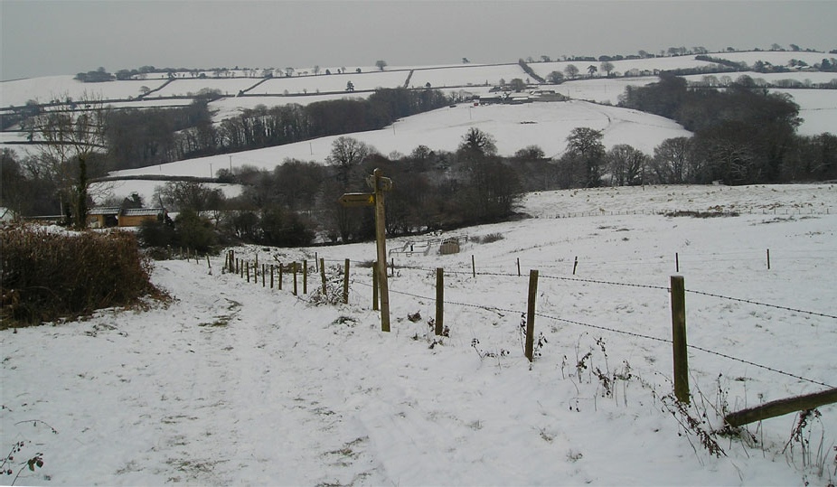
Starting opposite Sadborow Pound you can still follow this historic byway today.
Notice the width between the ruts, possibly made by cart wheels and more recently
worn away by tractors and agricultural machinery. Circumstantial evidence suggests
that was part of Thorncombe’s original road network may have been used by drovers.
Their job was to herd cattle and sheep to market from other parts of the country.
Hired by farmers, they were responsible for ensuring their charges arrived in tip
top saleable condition. The trade was at its height between the seventeen and nineteenth
centuries as the population increased, particularly in towns and demand for meat
and bi-products such as wool and animal hides grew. There was a small weekly market
in Thorncombe until 1773 and an annual six day fair starting on Easter Tuesday but
it is unlikely that the weekly market was sufficiently significant to attract large
numbers of cattle from other parts of the UK.
The coppiced tree lined parallel tracks running alongside Horseshoe Road and elsewhere
in the parish are said by some to be indicators of farm animals being herded through
the parish to be sold at local cattle markets 3. As they still do today, farmers
have been breeding, fattening and selling sheep in this valley for centuries. The
state of the roads and the extent of the traffic was such that alternative routes
away from main thoroughfares for sheep and cattle were essential to ease a herdsman’s
progress,
In 1808 Charles Vancouver in his General View of Agriculture of the County of
Devon describes the parish roads around Axminster as, ‘very indifferent, nay very
bad indeed.’ He comments on the ‘height of the hedge banks, often covered with a
rank growth of coppice wood, uniting and interlocking with each other over-head’
and complains that ‘gangs of pack horses’, the precursor of the dreaded white van,
either block the road or go at such a pace downhill they force the unfortunate traveller
into the hedge.
Continue along the track towards Saddle Street, to just above the self catering
units at Yew Tree Farm. The track links to a footpath which travels north-east down
into the valley. The path crosses the River Synderford into the water meadow; a natural
resting place for man and beast with a dependable supply of drinking water and grazing.
It then climbs up through Causeway Farm to Causeway. This road which hugs Blackdown
Hill links to the main Crewkerne/Lyme road providing easy access to the regular
weekly cattle and livestock markets at Crewkerne, Axminster, Bridport and beyond.
(Walk 4)
Another clue to the track’s possible use by drovers are Scots pine trees, still
growing along the Causeway and clearly visible across the valley. Like holly or
hollin, which often still marks the crossing of footpaths on old field boundaries,
these easy to spot trees are also ancient waymarkers. Natural regenerators, these
venerable trees appear to be ancient survivals of a world where few people could
read and write, besides which there were few accurate maps until the first ordnance
survey. Groups of Scots pines planted at the top of farm tracks are said to have
been a sign to a drover that he could rest his valuable charges overnight and find
hospitality in the farmhouse 4.
References
1. http://www.bl.uk/onlinegallery/onlineex/ordsurvdraw/
2. http://www.visionofbritain.org.uk/
3. Bonser, K., (1972), The Drovers …, Newton Abbot, Country Book Club
4. Mabey, R., (1998), Flora Britannica, London, Chatto & Windus
EVE HIGGS
November 2012
For a more detailed account see also Higgs, E. (2012) ‘A Thorncombe Bye-Way: An investigation’,
in Bliss, J., Jago, C., and Maycock, E., (eds.) Aspects of Devon History. People,
Places and Landscapes, Exeter, Devon History Society, pp. 149-165.